

Clear Air Long Loop Across Nevada to Utah and Back
Go West young man, Go West!
Horace Greeley’s advice to “Go West, young man, go West” is perhaps a little stale, as is our youth. My interpretation of his exhortation is fresh. It seems to me Horace was encouraging the expropriation the frontier in fulfilling the manifest destiny of westward expansion contained in the Monroe doctrine. Pete, Andy, and I don’t intend to conquer or exploit any lands or the people who occupy those lands, but maybe we’ll take advantage of a little pavement in warping Greeley’s advice as a small shift in his slogan provides raison d’être for a road trip.
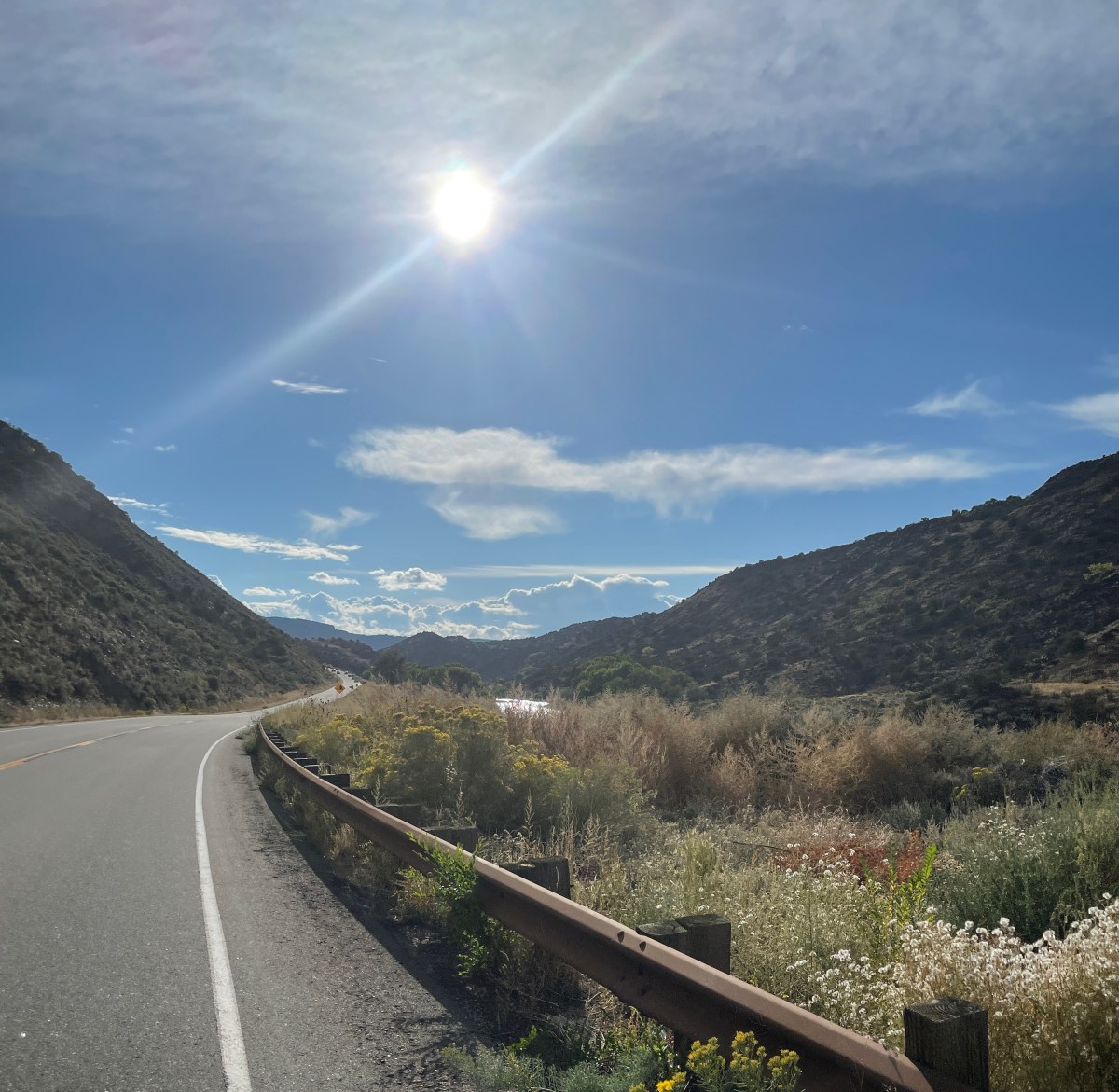
There’s not much adventure in sitting home watching YouTube videos of others out having adventures, or worse, the nightly news while breathing unhealthy to very unhealthy, to hazardous air in our smoke trapping, bathtub shaped San Joaquin Valley due to the western wildfires. Our saudade (from Portuguese folk culture), that deep emotional state of melancholic longing, in our case for a thing that is absent due to Covid and smoke, can only be rendered less severe with a road trip. In fact, there’s not much one can do to escape the dystopian trinity+one of covid induced death and illness, climate change induced infernos, politically induced social unrest, and 45’s narcissistic arrogance induced malign management of the past four years to make the dystopian trinity seem even more apocalyptic, except spending the day riding a motorcycle. For those of you who have a different opinion regarding 45, see Steve Martin on behalf of Yours Truly.
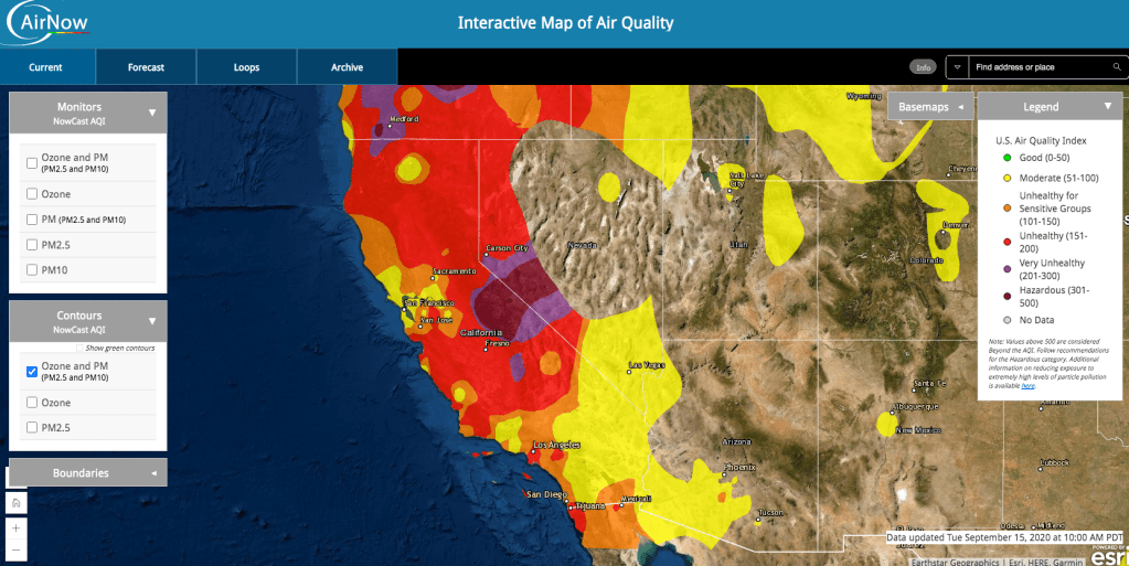
Given the Air Quality Map (see above from Sept. 15, 2020) I’m not sure what the air will be like in midish-October when Pete, Andy, and I have agreed (and have homestead clearance) to take a little road trip. It looks like our best bet, based on the combination of climate, fire, and geography, at least since the beginning of September, would be to consider Nevada and Utah. And so armed with masks and riding no closer than 6 feet apart we intend to Go East old fellas, go East!
And while our thoughts (cogito ergo sum) go out to the many whose families have had to endure the tragedy of coronavirus whether it be the loss of life, illness, or the financial impacts, the injury and loss of lives and property due to fires, hurricanes, and other natural (and not so natural) disasters, and the consequences of being the subject of the pillars of Caste about which Isabel Wilkerson writes, it is our in our hearts that we acknowledge your suffering and hope for your recovery.
Go East old fellas, go East!

Since my inspiration for touring on the moto was inspired by annual bicycle rides across the Western States and my deep appreciation and reverence for western landscapes, the route I’m pitching involves portions of three of those rides through California, Nevada, and Utah. That leaves Arizona, New Mexico, Colorado, Montana, Wyoming, Idaho, Washington, and Oregon for another at-bat. At this time, fire appears to discourage the Northwestern region and the changing seasons suggest a more central or southerly tour to witness the fall splendor before the wintery cold sets in.
Day 1, On or About October 11
Our first day of riding will take us over Sonora Pass because I just checked reservations for a day pass to travel over Tioga Pass through Yosemite and no passes are available during our travel window… Dang!
Once over Sonora Pass we’ll head south on US-395 to Lee Vining (at the eastern base of Tioga Pass, dang!) where we’ll head east on CA-120 through Benton to US-6/95 for miles and miles of range and basin through Coaldale and Millers to Tonopah. That’s 309 miles of big sky, some twisties over the Sierra, and miles of Nevada Style highways, in all, a full day’s ride to hopefully spend the night…
Merced to Tonopah Gas is available in Lee Vining, Benton, and Tonopah.
Day 2, On or About October 12
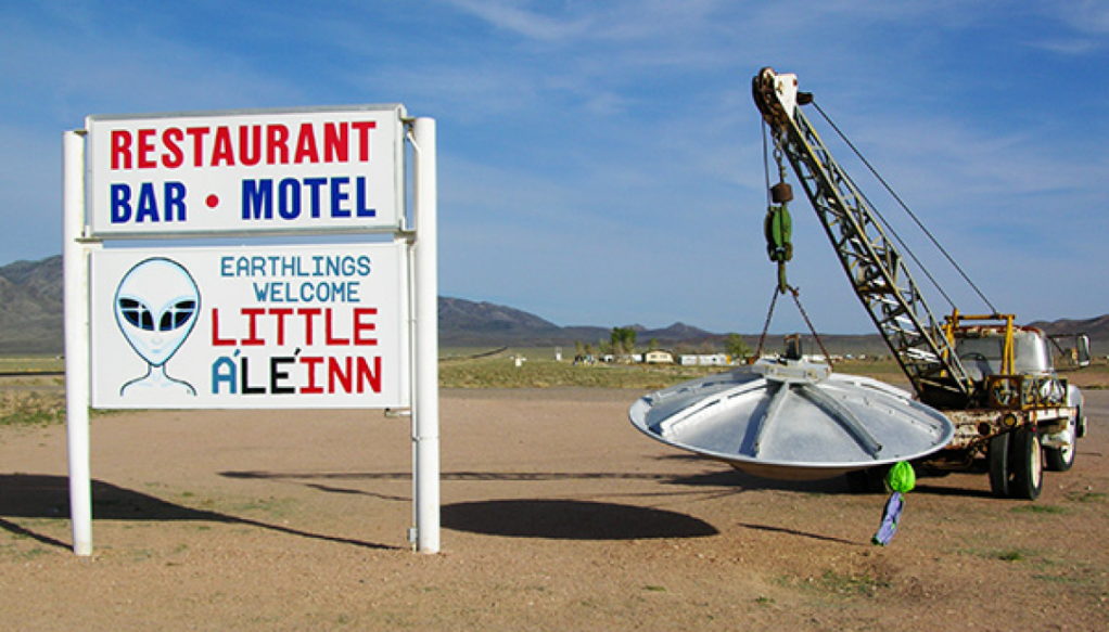
Day 2 will find us continuing on US-6 east to Warm Springs where we then head southeast on NV-365 through Rachel, home of the Little A’Le’Inn, to Crystal Springs and US-93. Nevada Style miles^2
Then it’s US-93 through Caliente to Panaca and NV-219 east to the Utah border where NV-219 becomes UT-56 10± miles to our first Utah settlement, Modena.
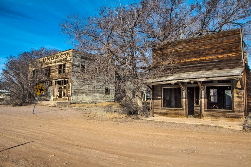
Not much to see in Modena so we’ll throttle on to Cedar City another ±52 miles (288 miles from Tonopah) on UT-56 maybe for the night. Since Cedar City is at 5,846 ft. we will likely find a good cheap (Covid discounted) motel in lieu of a frosty campsite.
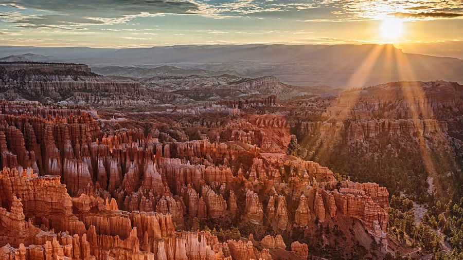
Or, we can press on another ±99 miles from Cedar City by way of UT-14, a little of US-89, and Ut-12 to Bryce at 7,664 ft. for equally cheap lodging in at the Roadway or Quality Inn at the intersection of US-89 and UT-12 in lieu of an even colder campsite. It’s only 361 miles, ±60% of which are Nevada Style miles. Plus a bonus: a day 3 side trip to Bryce Canyon the following morning. Piece of cake!
Gas is available in Tonopah, the Nevada/Utah border, Cedar City and Bryce.
Day 3, On or About October 13
Cedar City or Bryce to Torrey
Day 3 gets even more interesting IMHO. From Cedar City, should we elect to stay there, we travel on UT-14 and UT-89 the UT-12 to Bryce and visit Bryce Canyon National Park.
Cedar City to Bryce (Bryce Canyon) and Torrey
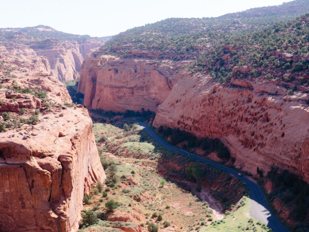
From Bryce Canyon we travel east on UT-12 through the unincorporated towns of Tropic, Cannonville, and Escalante to Boulder. In Boulder we take a side trip down the paved portion of the Burr Trail Road east to the west boundary of Capitol Reef, a 32 mile x 2 “detour” that will easily enter into the top 10 places to have been in one’s life (Right Chuck?). I was there on a bicycle ride across Utah in 1997 a year after the Grand Staircase-Escalante was declared a National Monument during the Clinton administration and it remains one of the most sublime places I’ve been.
After a breathtaking out and back–there is an option to take the unpaved, but graded gravel section of the Burr Trail north, back to Hanksville, but I’m not sure Andy’s Moto Guzzi Norge is set up for gravel or his back for washboard as are the Versys and V-Strom. I would imagine Pete and I would be feeling the washboard-back effect too. So we’ll likely continue north on UT-12 to Torrey making it a short but rewarding re(coefficient)* day of 254 miles, all on pavement.
*See the conclusion of this post for a discussion of the ride enjoyment (re) coefficient (rec) as a function of the s = d/t calculation effects on the ratio of riding passion to tush comfort and landscape appreciation (rp : tc + la).

Bullfrog Update:
Andy has just brought to my attention that his daughter is working in Bullfrog, Utah and he hasn’t seen her for 6 months. He asked about the possibility of visiting her. So, here’s an option from Bryce that will keep the side trip to Capitol Reef on the paved section of the Burr Trail. As I noted earlier, from where the pavement ends on the Burr Trail Road there’s a graded gravel washboard road for 35 miles, south, to the intersection with UT-276. From there it’s ±5 miles to Bullfrog. So that escalates the Escalante portion of our trip to 294 miles through Bryce, Boulder, Burr Trail Road, Torrey, and Hanksville to Bullfrog. A little less than half, Utah Style miles, some washboard-back assasins gravel.
Just to clarify, paved Utah Style miles are similar to Nevada Style miles, less the brothels.
Gas is available in Escalante, Boulder, and Torrey.
Day 4 On or About October 14
Torrey to Baker
Out of Torrey, seeking a more northerly route, we head up UT-24 through Bicknell, Lyman, Loa, Burrville, Sigurd, and just north of Ahrora to US-50 where it continues North to Scipio.
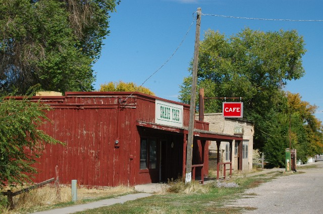
By now we’re road hardened and super ambitious inspired by Horace Greeley and we are heading west, so we will marshal on Westward to Baker, NV to spend the night. With all due respect to Scipio, Baker is mo hippa…
I think we should go for the Stargazer Inn and Kerouac’s Restaurant instead of the Border Inn, describe as “26 rooms plus a convenience store, gas station & bar with slot machines.” Baker is only 229 miles from Torrey, the last ±95 Nevada Style miles. Piece of cake!
Bullfrog Update:
If we make the Bullfrog leg of the trip, day 4 to Baker adds a few, Utah Style miles to the day as we retrace our route from Bullfrog to Torrey. From Torrey we’ll take the same paved route described above. Our 229 mile day grows by 114 miles to 343 miles for the day.

Gas is available in Torrey, Hanksville, Bullfrog, Scipio, Henkley, the border, and Baker.
Day 5, On or About October 15
Day 5 features some interesting Nevada Style route choices. You know, mile after mile of nothing but miles and miles over basin and range, Nevada style.
Baker to Lee Vining
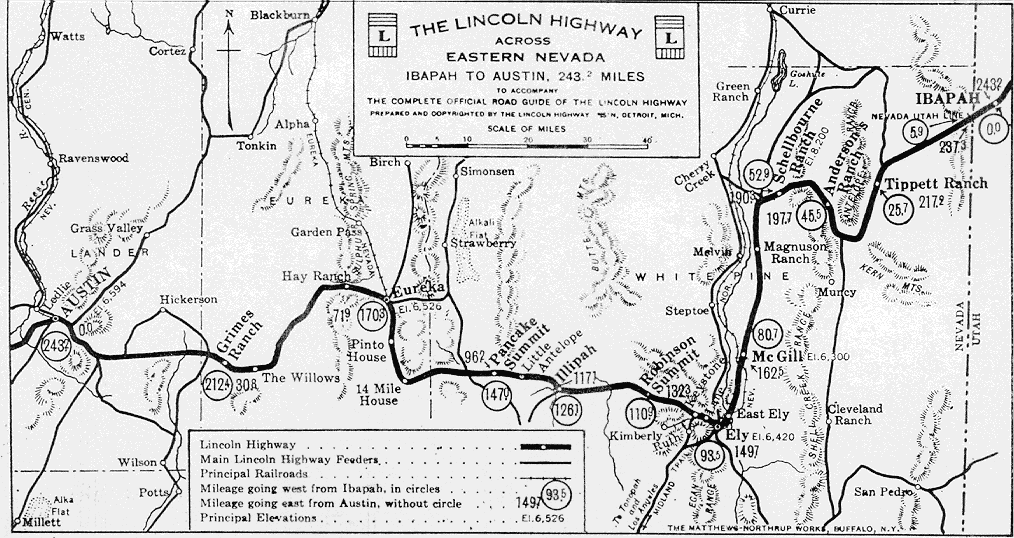
Leaving Baker we forge westward on US-50 a.k.a. the Lincoln Highway, a section that follows the first transcontinental road for automobiles in the United States that was dedicated in 1913. The route takes us through Major’s Place, Ely, Eureka, to the vicinity of Austin where a fork or two lie in the road. US-50 has the DNA of its ancestral Nevada Style highway, the L.

Our first option lies 12 miles East of Austin. After fueling up in Austin, we might choose to backtrack on US-50 and peel off on NV-376, a designated AAA scenic byway, back to US-6 just east of Tonopah. From there, we would retrace our outbound route retreating to Benton and Lee Vining. It’s only 455 Nevada Style miles. Piece of cake
Baker to Lee Vining via US-50 & the Scenic NV-376, US-6, & CA-120 Option 1
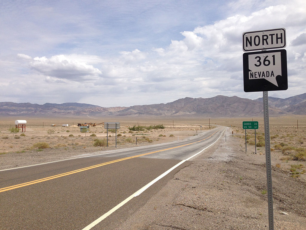
Our second option lies approximately 58 miles west of Austin in the town of Middlegate where we begin heading south on NV-361 to Gabbs and Luning. From there it’s up US-95 to Hawthorne and from Hawthorne it’s down NV-359 to the Nevada California border where it becomes CA-167 following along the north shore of Mono Lake and Mono City. From there it’s South on CA-395 then to Lee Vining after 421 Nevada Style miles, and we spend the night, perhaps where we stayed at the Lakeview Lodge on our Fool Moon Ride across Death Valley a year ago October.
Baker to Lee Vining Via US-50, NV-361, US-95, CA-167, & US-395 Option 2
Baker to Hawthorne

Option 3 is to stay in Hawthorne for the night, or not since Lee Vining is to Hawthorne what Baker is to Scipio. West of Austin we head south on NV-2/722 to Eastgate leaving US-50 for ±60 miles. A brief stretch on US-50 to NV-361 to Gabbs and Lunting then it’s north (west) on US-95 to Hawthorne. It’s only 353 miles. But it is Hawthorne, even though the miles are Nevada Style.
Baker to Hawthorne via US-50, NV 2/722 to Eastgate Option 3
Baker to Bridgeport
Then there’s the option 4 to ride from Baker to Bridgeport. It’s basically Option 2, but rather than heading south on US-395 to Lee Vining, since we can’t get a pass over Tioga Pass, we’ll head north about 25 miles to Bridgeport for the night before crossing over Sonora Pass on CA-108. 433 miles, Nevada style.
Baker to Yerington
Our last option is to follow the Baker to Hawthorn route (Option 3) and remain on US-95 through Hawthorne and take Alt-US-95 north another 58 miles passing Walker Lake to the town of Yerington, NV. This route sets us up to return to Merced over Monitor and Ebbitts Passes on CA-89 and CA-4. 417 miles, Nevada style. Just don’t drink the water…
Gas is available in Baker, Ely, Eureka, Austin, Middlegate, Hawthorne, Yerington, Lee Vining, and Bridgeport.
Day 6, On or About October 16
Since Tioga Pass is booked, we are left to cross the mighty Sierra either on CA-108, Sonora Pass or over Monitor CA-89 and Ebbitts CA-4 Passes.
Sonora Pass
Regardless of which Day 5 Option we will have chosen, Sonora Pass, CA-108, is accessible from US-395 whether approached from CA-120 from Benton, CA-167 from Hawthorne, or NV-208 from Yerington. Monitor Pass, CA-89, and Ebbitts, CA-4, are likewise approached from US-395. We are hoping to see these passes in their full fall splendor…
Lee Vining and Bridgeport to Sonora Pass

Yerington to Monitor and Ebbitts Passes


Hawthorne to Merced via Yerington over Monitor & Ebbitts Passes 259 miles (225 via Sonora Pass)
Lee Vining to Merced Over Sonora Pass 177 miles (228 miles over Monitor & Ebbitts Passes)
Bridgeport to Merced over Sonora Pass 152 miles (199 miles over Monitor & Ebbitts Passes)
St. Ignatius meets Descartes or how the Nevada Style & s = d/t affects the rec as a function of the ratio of tc + la to rp
Originally, I constructed the ride for to take place over 5 days. I suspect our posteriors will be pleased (see tc below) that I crunched some numbers and chose to add a day. Of course, we have allocated the possibility of a few additional days as all moto adventures are subject to any of the incalculable variables of infrastructure availability (gas and motels or campgrounds), weather, mechanicals, terrain, and fatigue. (That reminds me that Long Way Up debuts on Apple TV, 9/18/2020).
All moto adventures involve a little faith. Insert the Serenity prayer here: God, grant me the serenity to accept the things I cannot change, the courage to change the things I can, and the wisdom to know the difference. Similarly, all moto adventures involve a little reason. Insert a Descarte quote here: It is not enough to have a good mind; the main thing is to use it well. Let’s see how the I employ my mind to good use because riding by faith and not by sight is dangerous.
Considering the following variables might be a reasonable thing to do. We can at least change some of those variables, while maintaining faith and cohering to the wisdom that allows us to appreciate how the differences affect the ride enjoyment coefficient (rec). A quick perusal of the interwebs indicates riding 200 – 600 miles a day is reasonable given the many variables to consider. Our prior touring experience and timeframe puts us in an ideal ±300 mile range.
rec
Let’s begin by taking the average number of miles we’ll have to endure over the original 5 day pitch to make the 1,759 mile trip. Once we determine the average distance per day, we can arrive at the rec (ride enjoyment coefficient) represented by distance as affected by speed and time. And so distance equates to 1,759 miles/5 days yielding a rate of ±352 miles per day. That’s a tad over our ideal rec of 300 miles/day.
Ratio of rp to tc + la
Now, if we consider a 5 day trip with an average distance of 352 miles/day, speed, s (average mph) = d (our average daily distance of 352 miles) divided by t (the average number of hours we might consider per day of travel) let’s say 8 hours, we can determine the speed we’ll need to maintain to meet our 5 day goal. Therefore, s = 352mi./8hrs results in 44 mph over 352 miles for 8 hours in the saddle not accounting for stopping. In other words we would need to average approximately 44 mph over the 5 days averaging 8 hours per day of riding if that’s all we do is ride during those 8 hours. Doable I suppose, however with a low rec coefficient.
You’re thinking, this speed seems a little unreasonable considering a big chunk of those miles will be Nevada Style well in excess of 44 mph, so stopping for fuel, stretching, and a little sightseeing may necessitate speeding up. Let’s up the speed to 55 mph. 55 = 352/t resulting in ±6.4 hours saddle time/day on average. Speed has a nice effect on decreasing saddle time or tc while increasing la or sightseeing.
Averaging 55 mph, no doubt increases the rp (ride passion) ratio to tc and la (tush comfort and landscape appreciation) concurrently. Faster speed equates to greater ride satisfaction, less saddle time, thus providing for greater landscape inspection.
Let’s see what extending the ride to 6 days, one more day, and how that affects our average distance/day and the ratio of rp to tc & la … 1,759/6 = ±293 miles/day and if we maintain the 55 mph average, then 55 = 293/t would result in ±5.3 hours saddle time. We average of 293 miles over 6 days at 55 mph riding ±1.1 fewer hours in the saddle covering ±60 fewer miles each day. Seems a tad more comfortable on the fundament (tc) as in more time to stretch and more time to enjoy the vistas (la) while keeping good speed (rp)…
Now let’s look at how dropping the average speed to 50 mph for 6 days works on tc and la. 50 = 293/d would result ±5.86 hours in the saddle roughly a half-hour more than the 55 mph scenario, however at a slightly more leisurely pace while maintaining the ±60 fewer miles per day than at the 5 day rate of 352 miles per day, close to the 55 mph rate for the 6 days at 293 miles/day. Maybe there’s with a slight decrease in speed, there’s a proportional diminution of rp that’s related to a slight increase in la at 50 mph. I’m splitting hairs…
So, as we grapple with the speed, distance, and time variables (s = d/t) of the ride enjoyment coefficient (rec) we can appreciate that time clearly affects ratio of ride passion (rp) to comfort (tc) and landscape appreciation (la). Now it depends on what we can actually average in speed over the 1,759 miles in 5 or 6 days of mostly twisty California, a mix of twisty and Nevada Style roads in Utah, and Nevada Style basin and range roads in Nevada with decent weather and/or no mechanicals.
Blissful butts and scenic satisfaction while placating ramble rapture
Kind of like St. Ignatius meets Descartes. Stay tuned. The actual ride report is pending the actual ride…
